Club Tara is situated in Bucas Grande Island, the lone island municipality of Socorro in Surigao del Norte. It is a nearly 3-hour boat ride from General Luna in Siargao Island. Tourists from Siargao Island usually go to this destination not as a side trip but to explore it entirely.
The resort is by the sea and convenient to Kanlunes Beach and Sohoton Park. It is within the vicinity of Sohoton Lagoon. It features a private beach area, a restaurant and an outdoor swimming pool.
Watch CLUB TARA | BUCAS GRANDE video on TheTraveLad YouTube Channel here 👇🏻
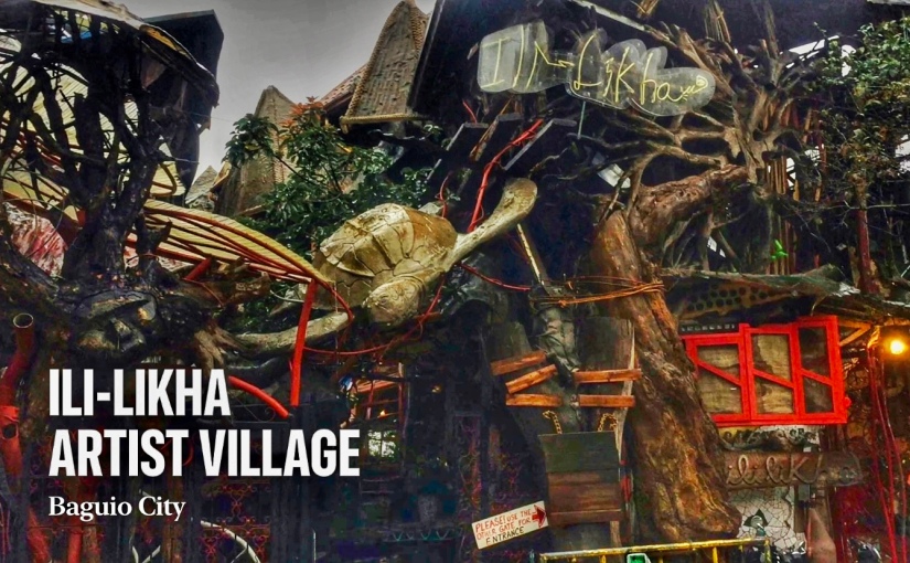
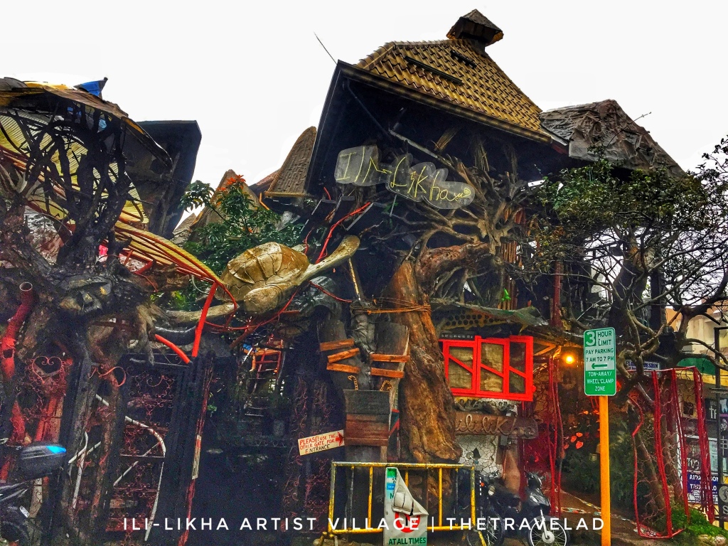
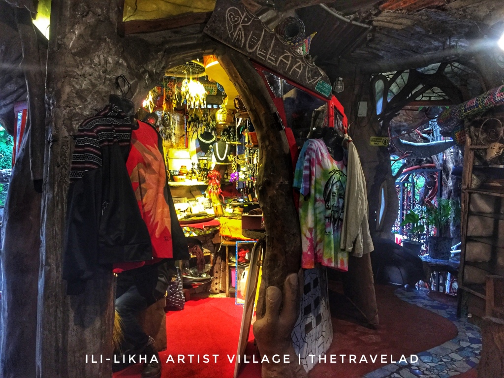
Conceptualized by film director, Eric De Guia or known as “Kidlat Tahimik”, ILI-LIKHA ARTIST VILLAGE is located along Assumption Road in Baguio City just near the Session Road. It is a food hub where good food and art collides.
The entire complex was completed over a 10-year period. For the length of a decade, it was a work in progress using a process Kidlat calls ‘pukpok tastas.’ Many artists—Ifugao woodcarvers, craftsmen and artisans including Kabunyan de Guia, Kawayan’s brother—helped create the structure.
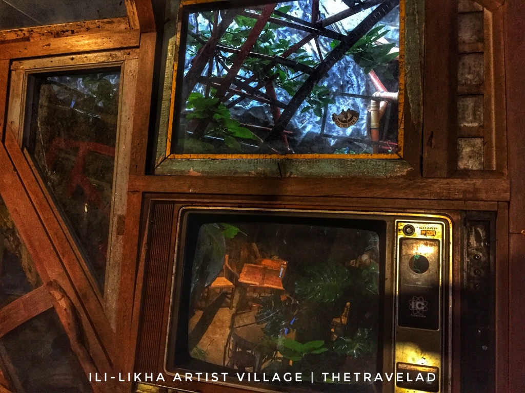
It’s built around trees and assembled from a host of materials. Used windows and old television frames make up walls, as do old kuwatro kantos bottles. Metal sculptures are used as foot bridge floors. Old bikes, colorful chairs, paintings, Rizal figures, broken tiles, flags and Ifugao statues. All of these complete the whole eclectic patchwork that is Ililikha. The whole building is a trip, in more ways than one.
Watch ILI-LIKHA ARTIST VILLAGE video on TheTraveLad YouTube Channel here 👇🏻
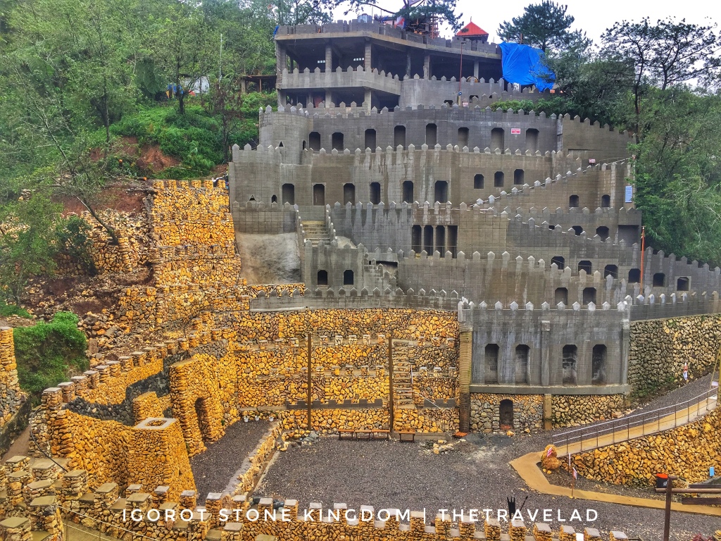
Located on the mountainside along Long-long Road, Pinsao Proper Village, Baguio City, Igorot Stone Kingdom showcases Igorot culture, practices and traditions as well as the life of the inhabitants of the Cordillera region.
The park covering a 6,000-square meter area features the Igorot ingenuity in creating stone walls similar to the rice terraces in Battad, Banaue.
Among the main attractions at the stone kingdom is a tower that depicts the fantasy story of Gatan and Bangan, an Igorot man and woman who survived the great holocaust, a fertility stone tower, and a Kabunyan (Igorot God) tower.
On the right side of the mountain facing the stone wall are modern-day castles made of cement and hollow blocks.
Watch IGOROT STONE KINGDOM video on TheTraveLad YouTube Channel here 👇🏻
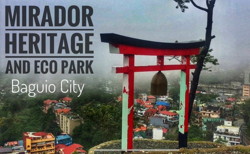
Here’s a new destination to visit in Baguio City – the Mirador Heritage and Eco Park. It is located at Mirador Hill near Lourdes Grotto and is open to the public, for locals and tourists who have completed the requirements needed to enter Baguio. The eco-park offers different attractions.
What’s inside Mirador Heritage and Eco Park?
✅Rock Gardens. At Rock Gardens, it’s an uphill hike through different rock formations. For safety purposes, use footwear suitable for hiking, and wear comfortable clothes.
✅Arashiyama Bamboo Grove: At Mirador Hill you can also Japan’s Arashiyama Bamboo Grove. This area is one of the relaxing parts of the eco-park and this is one of the best spots to take instagrammable photos.
✅Peace Memorial: The Mirador Hill’s Peace Memorial was inaugurated last December 2020. You can see the Torii Gate, a Bell which is repurposed from an unexploded bomb dropped during WWII at the Mirador Hill.
Watch MIRADOR HERITAGE AND ECO PARK video on TheTraveLad YouTube Channel here 👇🏻
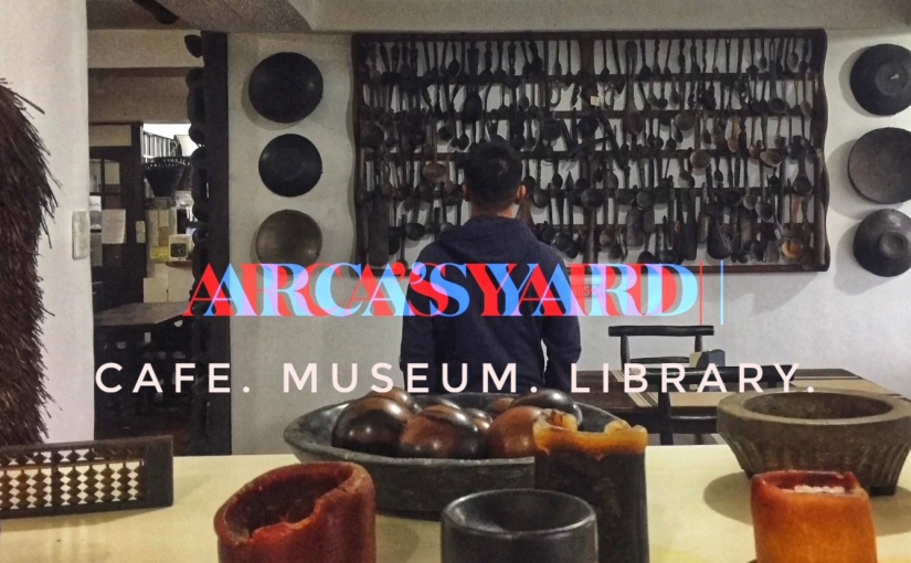
Located at 777 Tiptop City Limit, Ambuklao Road, Baguio City, Philippines, Arca’s Yard offers a majestic view 5,300 feet above sea level. It includes a cafe, a small museum and a library.
It has a wide collection of books, photographs, paintings, antique furnitures and artifacts of Cordillera region.
Tourists and residents of Baguio City usually go to Arca’s Yard to enjoy the tranquility of the mountainous view away from the urban busy life.
Watch ARCA’S YARD video on TheTraveLad YouTube Channel here 👇🏻
Mariveles is located at the southern tip of the Bataan Peninsula in the Philippines. The first class municipality which is divided into 18 barangays is about 173 kilometers from Manila.
Early morning view from Mariveles Baywalk
Interesting Facts You Might Not Know About Mariveles
Founded by a Franciscan Friar in 1578
Originally part of Pampanga but declared its independence though The Superior Decree of July 1754
It is the starting point of the famous “Bataan Death March” on April 9, 1942.
The first free trade zone in the Philippines was established in its town which was passed in Congress on June 21, 1969
Derived its name from ““Maraming Dilis” shortened to Mara-dilis and into Mariveles
Aside from its huge industrial complex of the Freeport Area of Bataan, its Mariveles Baywalk and its historical landmarks which include the Zero Kilometer Marker of Death March and the 1729 Parish Church of Saint Nicholas Tolentine, Mariveles prides itself of having the following wonderful natural attractions tourists can explore:
Mount Mariveles
The dormant volcano which lies at the southern end of the Zambalez Mountains in the Bataaan Peninsula, west of Manila Bay. Three peaks familiar to the mountaineering community namely:
Tarak Ridge – most well-known destination on Mount Mariveles with its jump-off point situated at Barangay Alas-sin, Mariveles.
Pantingan or Banayan Peak – can be accessed through Sitio Duhat, Saysain in the town of Bagac.
Mariveles Ridge – jump-off area at Sitio Parca, Mariveles.
Mount Mariveles as seen from Manila Bay
Five Fingers and the other coves
The finger-shaped west side of Mariveles, Bataan where the Japanese troops landed before the fall of Bataan on April 9, 1942. Five-fingers actually comprises six coves namely Talaga, Apatol, Nagbayog, Kinalalakhan, Kutad and Panoypoy. Three more coves follow Panoypoy along the coastline of Mariveles namely Talain, Lusong and Wain where Camaya Coast is situated. One can either trek or ride a boat doing cove to cove exploration.
Panoynoy Cove, a jeepney ride from Poblacion Mariveles to Porto Circle in Barangay Balon plus merely 20-minute trek
Hawla Beach, nearby beach from Panoypoy Cove
Talain Cove in Barangay Biaan, a 30-minute trek from Panoypoy Cove in Barangay Balon
Talain Falls, an hour and a half of gruelling trek to its destination
Creamy fine sand of Lusong Beach, a 30-minute boat ride from the shore of Barangay Biaan
Lower level of Lusong Falls which can be reached within 30 minutes of trekking
Sisiman
Just few minutes away from the Poblacion area, Barangay Sisiman shares its own picturesque view of its environment. Points of interest include Sisiman Beach, Sisiman View Deck, San Miguel Rock, San Miguel Lighthouse and the Sisiman Groto.
View of the bay and the San Miguel Rock at Sisiman View Deck
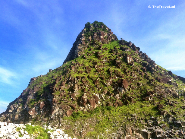
The stunning 700 feet high San Miguel Rock mountain
Mariveles, Bataan is three and a half hours away from Manila by car. You can take either the North Luzon Expressway (NLEX) or Subic-Clark-Tarlac Expressway (STEX). By bus, there are daily trips going to Mariveles in Cubao, Pasay and Manila.
TheTraveLad at Panoypoy Cove
Disclosure:TheTravelad personally writes his blogs for informational purposes. All photos and content provided in this blog are owned by TheTraveLad. Photos may not be used without permission. For more comments and suggestions, you can send an email to thetravelad@yahoo.com.ph
The long stretch beach of Bagasbas in Daet, Camarines Norte is a famous surfing and kite boarding spot. The Philippine Department of Tourism turned it into a local accredited surfing spot because of the attention it garnered from the local surfing community.
Early surfers of Bagasbas Beach
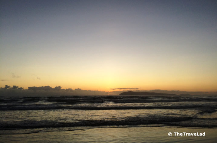
Sun about to rise at Bagasbas Beach
Fine grey sand stretches over Bagasbas Beach with waves of three feet up to eight feet. Best waves come in September to January. Beach is free, food is good and accommodations are cheap.
View of sunrise at Bagasbas Beach
Daily morning exercise of Bagasbas residents at the beach
Volleyball court setting up by beach goers
How to get to Bagasbas Beach?
Take the 8-hour bus ride bound for Daet (Superlines, DLTBCo., or PhilTranco) and get off at Daet town proper or Centro. From Centro, take a tricycle to Bagasbas Beach.
Disclosure:TheTravelad personally writes his blogs for informational purposes. All photos and content provided in this blog are owned by TheTraveLad. Photos may not be used without permission. For more comments and suggestions, you can send an email to thetravelad@yahoo.com.ph
Daet is the capital of the province of Camarines Norte in the Philippines. It is known as the “Gateway to Bicolandia”. It is a popular surfing spot among surfers worldwide. It is also home to the annual Daet International Aerosports Show.
Daet was derived from the Bicol word dai-daitan which means, close to each other. According to the first Bicol Spanish Dictionary Vocabulario dela Lengua Vicol authored by Fray Marcos de Lisboa, it means “to make friend” or “to be reconciled”. The municipality is rich in non-metallic mineral resources such as white clay.
The provincial capitol of Camarines Norte in the town of Daet
Points of Interest
Most Holy Trinity Cathedral: Built and was inaugurated in 1984. It is also the cathedral of the Diocese of Daet.
Parroquia de San Juan Bautista: Established in 1611, it is one of the first church in Camarines Norte in the region built by the Franciscan Friars.
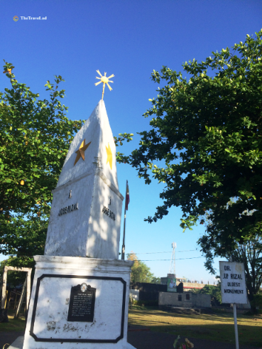
Oldest Rizal Monument: The first monument in honor of a Filipino hero, Dr. José Rizal which was unveiled on December 30, 1898.
Bagasbas Beach (Featured Image): Famous for its surfing and kite boarding spot with its long stretch of coastline.
The 405-year old Paroquia de San Juan Bautista church
First ever Rizal monument
How to go to Daet, Camarines Norte?
From Manila, you can travel by land and take the 8-hour bus ride bound for Daet (Superlines, DLTBCo or PhilTranco) and get off at Daet town proper.
Some sweet delicacies in Daet
*For places to stay in Daet, many cheap hotels are within the town proper. You can ask for assistance to the municipal office which is just across the oldest Rizal Monument.
Disclosure:TheTravelad personally writes his blogs for informational purposes. All photos and content provided in this blog are owned by TheTraveLad. Photos may not be used without permission. For more comments and suggestions, you can send an email to thetravelad@yahoo.com.ph
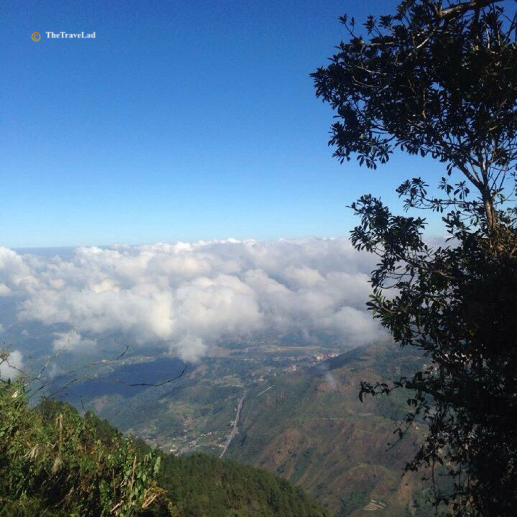
Known as the “Gateway to Baguio”, Tuba, Benguet lies at the southwestern tip of Cordillera Administrative Region. It is bounded on the north by the city of Baguio, on the east by the municipality of Itogon, on the south by the province of Pangasinan, and on the west by the province of La Union.
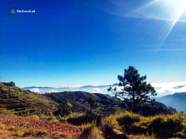
Sea of clouds and the view of Baguio City on the way to Mount Cabuyao
Tuba was part or the Baguio Township in the early part of 1900 during the American Regime. It is generally considered a mountainous area characterized by irregular rugged terrain and steep slopes.
Points of Interest
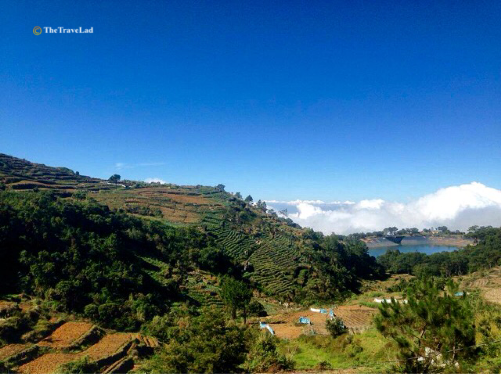
Mount Santo Tomas: The highest mountain in the town which soars to 2,252 meters above sea level.
Spectacular view of the mountain and water reservoir of Santo Tomas
Vegetation at Mount Santo Tomas
Mount Cabuyao: The shorter mountain beside Mount Santo Tomas where the two large satellite dishes of the Radar Station is located.
The Radar Station on top of Mount Cabuyao
Just another fantastic view at Mount Cabuyao
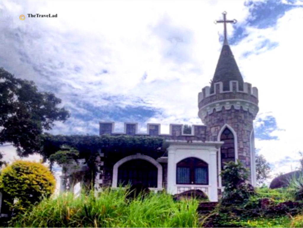
Bencab Museum: Located at Km. 6 Asin Road in Tuba, the museum promotes the arts, and the preservation, conservation and protection of the environment, as well as the culture and traditions of the Cordilleras.
Museum owned by Philippine National Artist Ben Cabrera
The garden at Bencab Museum
Bridal Veil Falls: The high falls along Kennon Road in Barangay Twin Peaks.
How to go to Tuba, Benguet?
From Manila, several bus lines ply the Metro Manila to Baguio route with terminals scattered across the metro. It generally takes about 6 hrs to get to Baguio by bus, longer than it would by car due to stops along the way. From Baguio City, numerous public transportation can bring you to its nearby town Tuba.
Notice: Since late last year, the government has stopped tourists from driving up to the community made popular by a television series in Mount Santo Tomas in order to enforce the permanent environment protection order imposed by the Court of Appeals on May 2015. News this August 2016, members of the Benguet board are eyeing to re-open Mount Santo Tomas for tourists. A resolution recently passed on first reading requesting the Department of Environment and Natural Resources (DENR) to allow tourist to visit the mountain again. (This trip was made possible by a friend’s relative in Tuba)
Disclosure:TheTravelad personally writes his blogs for informational purposes. All photos and content provided in this blog are owned by TheTraveLad. Photos may not be used without permission. For more comments and suggestions, you can send an email to thetravelad@yahoo.com.ph
The Monasterio de Tarlac is a well-known tourist destination in the province of Tarlac in the Philippines. The monastery is located at the 278-hectare Tarlac Ecotourism Park in Brgy. Lubigan, San Jose. It is run by the Servants of the Risen Christ Monastic Community.
The Admin and Information Office
View of Mount Damas from Monasterio de Tarlac
Construction of Monasterio de Tarlac started at the end of 2000. The monastery holds a relic of the Holy Cross and is the only one known to possess such in Asia. In 2005, the relic came to the monastery and was enshrined beneath the chapel’s altar in January 30, 2007. The said relic is believed to be part of the cross discovered in Jerusalem by Helena, mother of Constantine The Great.
The chapel where the relic is located
Prior’s hermitage
There is no entrance fee to the monastery and it is open to the public daily from 7:00AM to 6:00PM. Masses are celebrated at 10:30 am daily (except Thursdays) and at 3:00 pm on Sundays.
Barricade in front of the altar protecting the relic
Beneath the altar is where the relic of a piece of the one true cross was placed
How to get to Monasterio De Tarlac?
From Manila, take the North Luzon Expressway, exit Sta. Ines Toll Plaza in Mabalacat, Pampanga. Proceed towards north to Tarlac City. Upon reaching Brgy. San Sebastian, take a left turn to the bypass road (Tarlac – Pangasinan) towards the town of Camiling. Follow the 36-km road to Brgy. Lubigan in San Jose, Tarlac (refer to the markers and signs on the road). Travel time takes 2-3 hours if via TPLEX.
Monasterio de Tarlac Information Office at +63 916 2508414 or landline at +63 (45) 4933002
Featured Photo:Monasterio de Tarlac’s 30-foot statue of the Risen Christ on top of Mount Resurrection, part of the Zambales Mountain Range.
Disclosure:TheTravelad personally writes his blogs for informational purposes. All photos and content provided in this blog are owned by TheTraveLad. Photos may not be used without permission. For more comments and suggestions, you can send an email to thetravelad@yahoo.com.ph